Social Media
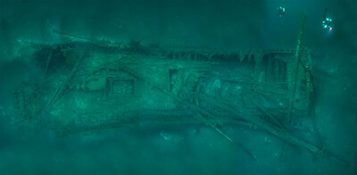
#MosaicMonday continues with the Norman.....
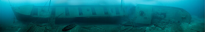
Thunder Bay’s infamous fog contributed to a tragic collision one May morning in 1895, claiming the lives of three sailors. Approximately seven miles off Lake Huron’s Middle Island, the freighter Norman and the steamer Jack collided with enough force to cut the larger freighter almost in two.
In less than three minutes, the nearly 300-foot Norman plummeted to its current location, 200 feet below the surface of Lake Huron. It wasn’t until 1986 that the wreck was located and work could begin archaeologically recording this intriguing piece of Great Lakes maritime heritage.
Today, one lifeboat remains at the wreck site, lying askew and to port of the massive freighter. Even immobile on the lake bottom, the Norman’s size is impressive. With a net tonnage of 1,870, the steel vessel hauled thousands of tons of bulk material in its short, five-year career. Other significant features evident today are the once-tall forward deck house, which lies collapsed in the mud near the port bow, and the triple-expansion steam engine peeking out of the broken aft decking. Much of the below decks area is accessible.
At a 200-foot depth with water temperature on site hovering between 38-45 degrees Fahrenheit, the Norman is a challenging technical dive. It is also one of hundreds of shipwrecks that make up northeastern Michigan’s diverse maritime landscape.
"Tide" up with work?
Start planning a trip! NOAA's Greater Farallones National Marine Sanctuary is full of amazing habitats and exciting adventures.
From a fun day at the beach, boating trips, and even virtual visits; there are many ways to enjoy your marine sanctuary and truly something for everyone!
(Photo: Anna Sparer)
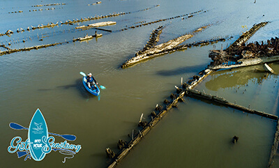
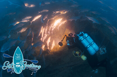
Showcase the beauty of your sanctuary with the "Get Into Your Sanctuary Photo Contest"!
From May 23 through September 7 (Memorial Day weekend to Labor Day weekend), send us your best photos of the National Marine Sanctuary System and help us celebrate the beauty and importance of these special places.
Winning photos will be featured in next year's Earth Is Blue Magazine and on the Earth Is Blue social media campaign.
Check out the 2019 1st place winner from the "Sanctuary Life" category! Photo by Bruce Sudweeks.
Check out this kelp canopy kaleidoscope in NOAA Olympic Coast National Marine Sanctuary!
#MosaicMonday continues with the steam barge Messenger. When the steam barge Messenger caught fire at a dock in Rogers City it was cut free and allowed to drift out into the lake where it finally sank about 4 miles offshore. Its burnt hull sits upright on the lake bottom with rudder, engine and anchors still in place.
*This is how we row!*
In 2019, NOAA designated an 18-square mile stretch of Maryland’s Potomac River Mallows Bay-Potomac River National Marine Sanctuary. It is the first national marine sanctuary designated since 2000 and protects the remnants of 118 World War I-era wooden steamships and vessels as well as other significant maritime heritage resources.
Plan a trip to explore the nature trails, birdwatch, or paddle among the ghost fleet!
(Photo: Matt McIntosh/NOAA)

#MosaicMonday continues with the wooden schooner Corsican.....
On the foggy morning of June 2nd, the steel steam barge Corsica collided with the schooner Corsican off Thunder Bay. The schooner was nearly cut in two and went to the bottom instantly with its entire crew. The cabin and stern of the wreck are badly damaged with large sections missing and piles of jumbled wreckage above the deck. The wheel with steering box is wrenched upwards and no longer attached to the rudder. Deck hatches are still intact revealing a coal cargo and the entire deck has collapsed into the hull. The bow windlass, still wrapped with anchor chain, and a capstan remain upright.
For the next few weeks, we'll be sharing a photomosaic of a shipwreck that lies in the waters of NOAA Thunder Bay National Marine Sanctuary. Tune in next week!
Photomosaics are a great way to look at shipwrecks. It's a picture made up of many smaller pictures; these smaller pictures are pieced together to create a larger image of the whole shipwreck. This image gives archaeologists a view of the shipwreck just as it is underwater. Because visibility (how far you can see in water) can be poor and wrecks can be big, taking many small images of a shipwreck and piecing them together is a great way to see all the detail of the whole wreck all at once!
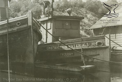
The tugboat Freedom, built in 1892. This 64-foot vessel had a long life on the Great Lakes. It was abandoned in 1946 in Duluth, Minnesota.
Happy Fourth of July from NOAA Thunder Bay National Marine Sanctuary!!
Photo: C. Patrick Labadie Collection in the Thunder Bay Sanctuary Research Collection at Alpena County George N. Fletcher Public Library
#SitePlanSaturday continues today with the wooden steam barge Monohansett!
Built as the double-decked bulk freighter IRA H. OWEN, the ship was rechristened Monohansett in 1882. Ten years later, it was rebuilt as a single-decked lumber carrier. On November 23, 1907, the ship burned to the water's edge at Thunder Bay Island. Most of the crew lost their personal belongings and some suffered minor burns, but there was no loss of life because the ship was near the island’s Life Saving Station. Today, the MONOHANSETT's wreck lies in three sections. The stern portion has hull features, propeller, and shaft all in place, and the boiler is nearby.
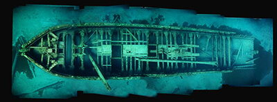
For the next few Saturdays, we will share an archaeological site plan from a sanctuary shipwreck. A site plan is a carefully measured drawing that archaeologists make of a shipwreck and the artifacts on or around the shipwreck. Site plans help archaeologists see how the whole site looks. They can tell exactly where parts of the ship are in relation to other things onboard and around the site. Archaeologists can also see from site plans how the ship was built. This can be a challenge underwater because ships can be large, in scattered pieces, or covered with life like zebra mussels.
Swim back in time with NOAA Monitor National Marine Sanctuary!
Originally designated to conserve the sunken Civil War ironclad USS MONITOR, this archaeological gem on the East Coast is surrounded by thousands of historic shipwrecks as part of the famed “Graveyard of the Atlantic.” Today, many of these wrecks serve as artificial reefs that are home to lots of marine life!
While you can view some of these wrecks by snorkeling and scuba diving, you don’t have to get your feet wet. Visitors centers like The Mariners' Museum in Newport News, Virginia, offer plenty of opportunities to explore Monitor National Marine Sanctuary and the Graveyard of the Atlantic.
(Photo: NOAA)
#MosaicMonday continues with the Lucinda Vanvalkenburg.
The Lucinda Vanvalkenburg was built in 1862……25 years later it was lost on Lake Huron. Bound for Chicago with a load of coal, it was struck by the iron propeller LEHIGH about 2 miles northeast of Thunder Bay Island. The crew was picked up by the Lehigh and taken to Port Huron. For a time, the sunken Lucinda Vanvalkenburg presented a dangerous obstruction to other vessels, as the masts remained standing high out of the water from just below the crosstrees.
For the next few weeks, we'll be sharing a photomosaic of a shipwreck that lies in the waters of NOAA Thunder Bay National Marine Sanctuary. Tune in next week!
Photomosaics are a great way to look at shipwrecks. It's a picture made up of many smaller pictures; these smaller pictures are pieced together to create a larger image of the whole shipwreck. This image gives archaeologists a view of the shipwreck just as it is underwater. Because visibility (how far you can see in water) can be poor and wrecks can be big, taking many small images of a shipwreck and piecing them together is a great way to see all the detail of the whole wreck all at once!

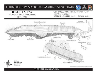
#SitePlanSaturday continues today with Joseph S. Fay.
With the D.P. Rhodes in tow, the giant bulk freighter Joseph S. Fay encountered a strong gale in northern Lake Huron. Fay hit the rocks at 40 Mile Point, the towline parted and the Rhodes met a similar fate at Cheboygan. The Fay broke apart quickly and its lower hull still containing a load of iron ore sits in shallow water not far from shore, while a large portion of the starboard side is located on the beach just up the shore from the lighthouse.
For the next few Saturdays, we will share an archaeological site plan from a sanctuary shipwreck. A site plan is a carefully measured drawing that archaeologists make of a shipwreck and the artifacts on or around the shipwreck. Site plans help archaeologists see how the whole site looks. They can tell exactly where parts of the ship are in relation to other things onboard and around the site. Archaeologists can also see from site plans how the ship was built. This can be a challenge underwater because ships can be large, in scattered pieces, or covered with life like zebra mussels.
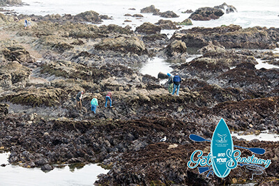
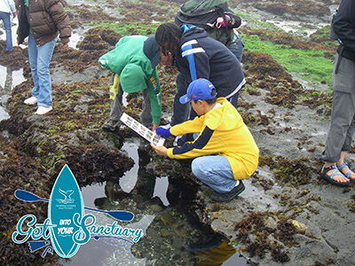
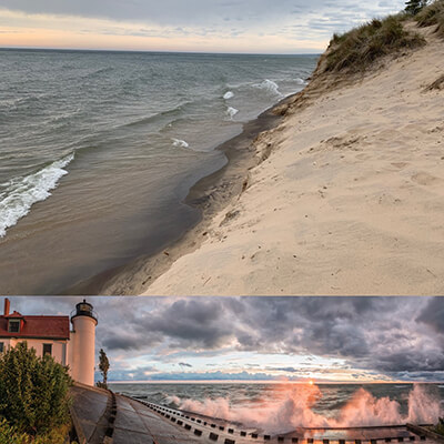
Looking to get "tide" up in Monterey Bay National Marine Sanctuary? Go no further than the sanctuary's rocky shores and tide pools. During low tide, it's a great place to discover sea life without getting wet!
Plan your trip to meet some of the fascinating plants and animals that survive in this rugged and changing seascape. Learn more and plan your trip here.
(Photo: Robert Schwemmer/NOAA)
*Calling all Photographers and Marine Sanctuary enthusiasts!*
*Get Into Your Sanctuary Photo Contest*
Show the world what the ocean and Great Lakes mean to you!
In celebration of national Get Into Your Sanctuary activities, NOAA's Office of National Marine Sanctuaries is hosting a photo contest. From May 23 through September 7 (Memorial Day weekend to Labor Day weekend), send us your best photos of the National Marine Sanctuary System and help us celebrate the beauty and importance of these special places.
Winning photos will be featured in next year's Earth Is Blue Magazine and on the Earth Is Blue social media campaign.
For more information on the contest and to view the photo categories, visit the National Marine Sanctuaries website!
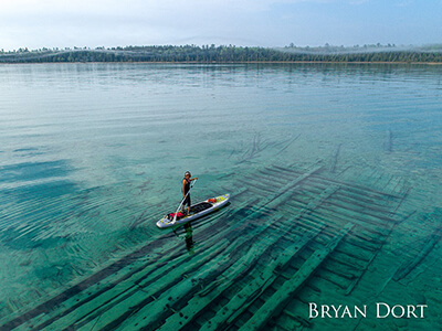
Check out the 2018 first-place winner from the “Sanctuary Portraits” category! Photographer: Bryan Dort
Check out this webinar from our friends at the Michigan Historic Preservation Network featuring State of Michigan Maritime Archaeologist Wayne Lusardi. Register here and see you tomorrow!
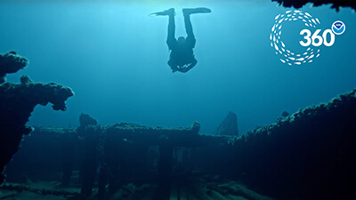
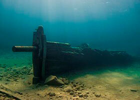
Dive under the surface of Lake Huron, even if you’re anchored at home! Take a virtual tour of D.M. Wilson in Thunder Bay National Marine Sanctuary.
Explore the 125-year-old freighter and see if you can spot the windlass, used to hoist the anchor, on your tour.
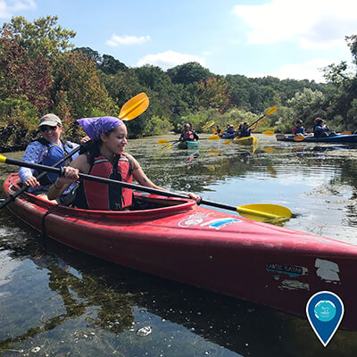
Plan a visit to Thunder Bay National Marine Sanctuary, where you can enjoy the nearly 200 shipwrecks and artifacts by snorkeling, kayaking, diving, and more!
#MosaicMonday continues with the John J. Audubon......
The schooner Defiance was down bound from Chicago with 11,500 bushels of corn when, in a dense fog, was run into by the Audubon laden with 401 bars of railroad iron. Both ships went down a few miles apart. Although the AUDUBON's stern cabin is missing the deck combing and three cargo hatches remain in place. The foremast with square rigged yards has fallen, and the mainmast, intact to the cross trees, is laying across the deck. Rail iron is haphazardly strewn across the deck.
For the next few weeks, we'll be sharing a photomosaic of a shipwreck that lies in the waters of NOAA Thunder Bay National Marine Sanctuary. Tune in next week!
Photomosaics are a great way to look at shipwrecks. It's a picture made up of many smaller pictures; these smaller pictures are pieced together to create a larger image of the whole shipwreck. This image gives archaeologists a view of the shipwreck just as it is underwater. Because visibility (how far you can see in water) can be poor and wrecks can be big, taking many small images of a shipwreck and piecing them together is a great way to see all the detail of the whole wreck all at once!
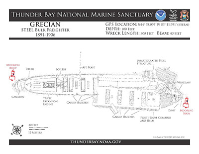
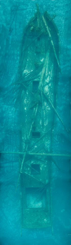
#SitePlanSaturday continues today with the steel freighter Grecian!
On June 7, 1906 the Grecian struck a rock and sank in shallow water at Detour Village in the St. Mary’s River. The ship was later refloated and taken in tow by the steamer Sir Henry Bessemer, en route to Detroit for repairs.
Unexpectedly, it filled with water and sank near Thunder Bay Island. Its crew escaped in lifeboats. Today the Grecian’s bow and stern lie intact, while the midships portion has collapsed. The engine, boiler, portions of the propeller and deck machinery are all in place. There is also a steel canalon (salvage lifting device) lying off the vessel’s stern from a 1909 salvage attempt.
For the next few Saturdays, we will share an archaeological site plan from a sanctuary shipwreck. A site plan is a carefully measured drawing that archaeologists make of a shipwreck and the artifacts on or around the shipwreck. Site plans help archaeologists see how the whole site looks. They can tell exactly where parts of the ship are in relation to other things onboard and around the site. Archaeologists can also see from site plans how the ship was built. This can be a challenge underwater because ships can be large, in scattered pieces, or covered with life like zebra mussels.
#MosaicMonday continues with the wooden schooner Cornelia B. Windiate.
For many years, the story of the Windiate’s disappearance was a mystery. It was thought to have gone down in Lake Michigan, since it was spotted there in a fall gale and was never seen again. More than 100 years later, the wreck was discovered deep in Lake Huron’s waters. The ship is in nearly perfect condition with masts upright, cabin intact, and the yawl boat lying alongside the stern. The Windiate is now thought to have sunk because heavy seas covered the decks in ice causing it to settle slowly to the bottom of the lake. No sign of the eight crewmen have ever been found.
For the next few weeks, we'll be sharing a photomosaic of a shipwreck that lies in the waters of NOAA Thunder Bay National Marine Sanctuary. Tune in next week!
Photomosaics are a great way to look at shipwrecks. It's a picture made up of many smaller pictures; these smaller pictures are pieced together to create a larger image of the whole shipwreck. This image gives archaeologists a view of the shipwreck just as it is underwater. Because visibility (how far you can see in water) can be poor and wrecks can be big, taking many small images of a shipwreck and piecing them together is a great way to see all the detail of the whole wreck all at once!
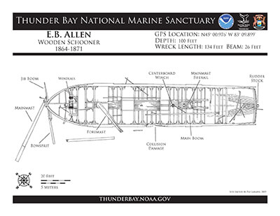
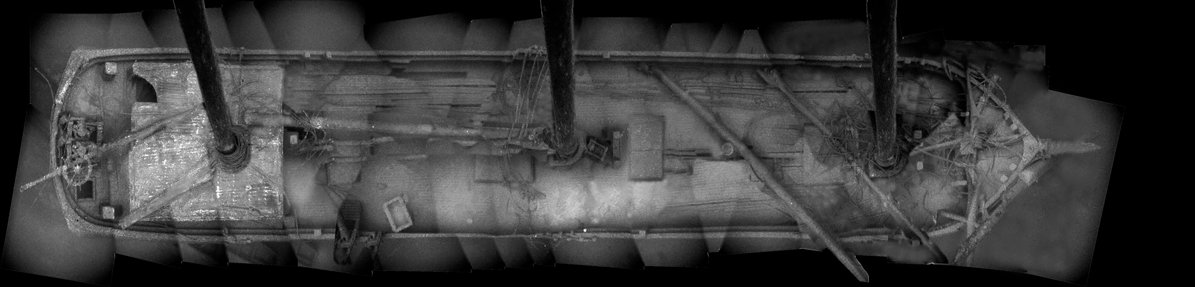
#SitePlanSaturday continues today with the schooner E.B. Allen!
On its last voyage, the E.B. Allen was bound for Buffalo, New York, carrying a cargo of grain. When it was about 2 miles southeast of Thunder Bay Island, it met the bark Newsboy in heavy fog. The two ships collided, and the Newsboy tore a large hole in the ALLEN’s portside. As the ship began to sink, the ALLEN’s crew was removed and taken on board the other vessel. Today, the E.B. Allen sits on an even keel, with its hull largely intact. Although the masts are broken and most of the decking is gone, the windlass, anchor chains, and rudder are still in place.
For the next few Saturdays, we will share an archaeological site plan from a sanctuary shipwreck. A site plan is a carefully measured drawing that archaeologists make of a shipwreck and the artifacts on or around the shipwreck. Site plans help archaeologists see how the whole site looks. They can tell exactly where parts of the ship are in relation to other things onboard and around the site. Archaeologists can also see from site plans how the ship was built. This can be a challenge underwater because ships can be large, in scattered pieces, or covered with life like zebra mussels.

Time for a #photocontest!! Show the world what the ocean and Great Lakes mean to you!
In celebration of national Get Into Your Sanctuary activities, NOAA Office of National Marine Sanctuaries is hosting a photo contest. From May 23 through September 7 (Memorial Day weekend to Labor Day weekend), send in your best photos of the National Marine Sanctuary System and help us celebrate the beauty and importance of these special places.
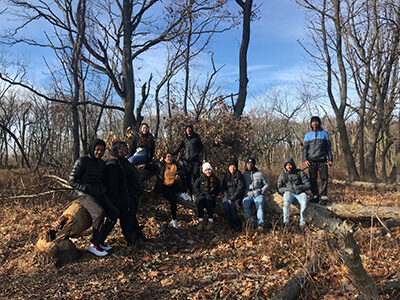
Great work by students and educators across the Great Lakes!
#MosaicMonday continues today with the massive freighter Florida.
On May 21, 1897, the steamer Florida sank in a collision with the steamer George W. Roby off Middle Island in Thunder Bay. The ship went down in deep water and was nearly cut in half by the collision. Today, Florida sits upright on the lake bottom and still contains much of its package freight.
Welcome to #SitePlanSaturday! For the next few weeks, we will share an archaeological site plan from a sanctuary shipwreck every Saturday.
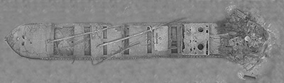
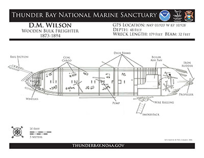
On October 27,1894, the wooden bulk freighter D.M. Wilson was headed for Milwaukee loaded with coal when it sprang a leak and began to sink. The steamers Hudson and Samuel Mitchell took it in tow, but it foundered in 40 feet of water two miles north of Thunder Bay Island. The crew was rescued by a fourth ship. The WILSON was broken up by a gale 10 days later, and debris was driven as far south as Tawas. Much of the machinery was later salvaged. Most of the WILSON’s hull remains intact today, including a large windlass that rests on the bow.
EXCITING NEWS! Stay tuned on June 8 to the NOAA Office of National Marine Sanctuaries Sanctuaries 360 page to see the launch of the D.M. Wilson in 360 video!!
A site plan is a carefully measured drawing that archaeologists make of a shipwreck and the artifacts on or around the shipwreck. Site plans help archaeologists see how the whole site looks. They can tell exactly where parts of the ship are in relation to other things onboard and around the site. Archaeologists can also see from site plans how the ship was built. This can be a challenge underwater because ships can be large, in scattered pieces, or covered with life like zebra mussels.
Enjoyment and appreciation of the great outdoors is a fundamental American value. Like our iconic national parks, national marine sanctuaries are places of hope, inspiration, biodiversity, and resilience. But they are more than just ocean parks; they’re communities with diverse cultures, values, and ideas. By embracing and celebrating this diversity, we can ensure a bright future of our ocean and Great Lakes for current and future generations.
Whether you live on a coast or in a community far from the shore, we invite you to experience the power and beauty of America’s sanctuary system and form your own lasting memories. (Photo: NOAA)
June 2, 1893:
A morning fog envelops northwestern Lake Huron. The two-masted schooner Corsican is sailing by Thunder Bay with a load of coal, when out of the mist the steel steam barge Corsica rams the wooden schooner, nearly cutting it in half.
Corsican went to the bottom in an instant, taking with it the entire crew.
Today the schooner lies at a depth of 160 feet, with deck hatches still intact. The bow windlass, still wrapped with anchor chain, and a capstan remain upright. Rigged spars rest atop the wreckage and the steering box is wrenched upwards and no longer attached to the rudder.
Learn more at the sanctuary's shipwreck pages
Celebrate the ocean this June!
Join us all month long to celebrate and learn about our world ocean during National Ocean Month
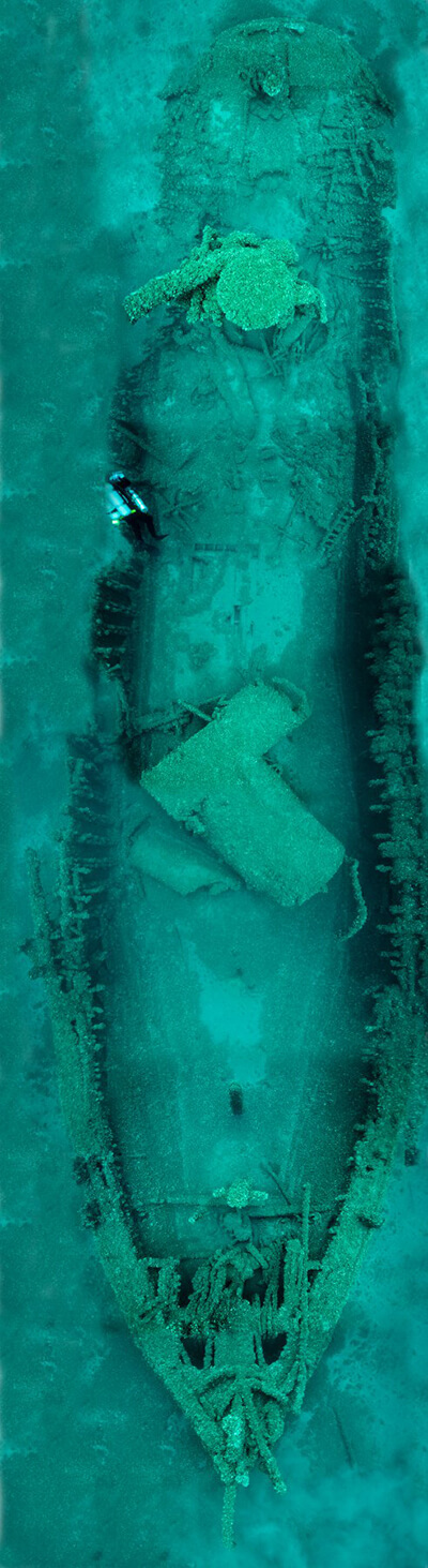
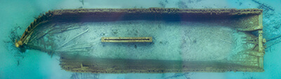
Welcome to #MosaicMonday! For the next few weeks, we'll be sharing a photomosaic of a shipwreck that lies in the waters of NOAA Thunder Bay National Marine Sanctuary.
On its last voyage, E.B. ALLEN was bound for Buffalo, New York, carrying grain. About 2 miles southeast of Thunder Bay Island, it met the bark NEWSBOY in heavy fog. The two ships collided, and NEWSBOY tore a large hole in ALLEN’s portside. As it began to sink, ALLEN's crew was taken on board the other vessel. Today, E.B. ALLEN sits on an even keel, with its hull largely intact. Although masts are broken and most of the decking is gone, the windlass, anchor chains, and rudder are still in place.
Photomosaics are a great way to look at shipwrecks. A photomosaic is a picture that is made up of many smaller pictures; these smaller pictures are pieced together to create a larger image of the whole shipwreck. This image gives archaeologists a view of the shipwreck just as it is underwater. Because visibility (how far you can see in water) can be poor and wrecks can be big, taking many small images of a shipwreck and piecing them together is a great way to see all the detail of the whole wreck all at once!